

By Tristan Marks
NewsNow
West Lincoln residents had another chance to give their input into the ongoing Smithville Master Community Plan study at a second Public Information Centre (PIC) held virtually last Wednesday, Oct. 6.
Township of West Lincoln staff gave an update on the plan, explaining how they made use of feedback received at the first PIC held in February of this year, and answered questions related to this new information.
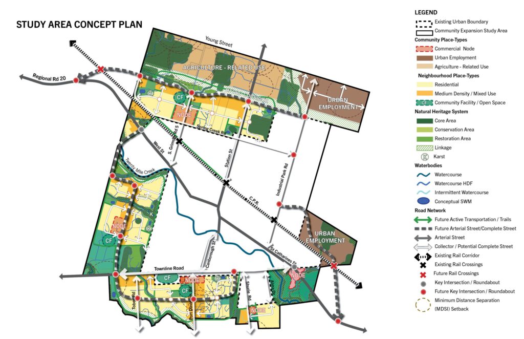
The project seeks to create a vision for land use in the future expanded urban boundary of Smithville. As the plan stands, the community’s current borders will expand up to Young St. to the north, west to South Grimsby Rd. 6, and to a number of plots past Townline Rd. to the south.
The presentation noted that participants of the February PIC were asked for their preference of two options for assigning residential and employment zones. This time around staff moved forward with the most preferred option, which favours slightly more residential/mixed use zoning. This is mostly concentrated along the west and south of the urban expansion, leaving a large strip of land to the north, between Reg. Rd. 20 and Young Street for urban employment lands.
Staff unveiled a more detailed concept map which shows specific zoning for various kinds of residential use, community facilities, natural heritage greenspaces and so on. Consultant Steve Wever explained that under this plan, 32 per cent of the new urban area would be used for residential mixed use, 34 per cent would be left for natural heritage and 21 per cent would be used for new employment lands, leaving the rest for various other types of land use.
Overall the plan is to grow the urban settlement area of Smithville to accommodate approximately 22,000 people and 5,500 jobs by 2051.
The PIC also delved into plans to grow the transportation network within an expanded Smithville. The transportation modeling is based off of transportation trends, which are then extrapolated to match Smithville’s projected population in 2051.
Consultant Ed Stubbing explained that the transportation study looks at a number of scenarios based on these data points.
“What we found is that even in a scenario where the urban boundary expansion doesn’t happen, there’ll be a significant increase in traffic in the town of Smithville,” said Stubbing.
He explained that this analysis will help the Township to plan ways to mitigate this increased traffic with new road networks, railroad crossings, a truck bypass and more.
“The truck bypass is the most discussed and most anticipated strategy,” said Stubbing.
As with previous presentations on this topic, Stubbing noted that the study has identified three main options for creating a truck bypass for Smithville. Two involve east-west routes on the north edge of the community and connecting to the QEW. The third option involves a similar east-west route to the south of Smithville. However the consultant was quick to point out that all three options are just concepts.
“These options are not to say that these are going to be the fixed routes,” said Stubbing, who explained that they are models to see how different route arrangements might mitigate traffic and do not necessarily indicate a final design.
The PIC also touched on studies on the local subwatershed, water pumping system and wastewater system.
The subwatershed study is still ongoing, and is helping map the natural heritage system including environmental features and important corridors that link natural heritage cores together.
The findings from this study will help finalize what land-use will go where in Smithville’s expanded urban area.
Both the water and wastewater studies examine how to bring water and sewage routes to the new urban area, what needs to be upgraded in the existing system and where to place new pumping stations. Both systems will make use of new road construction to where possible to lay out the needed infrastructure. Stubbing said that the wastewater study specifically suggests creating new sewer lines that avoid the existing system to prevent over-stressing those older lines.
After the presentations, the PIC opened up to accepted questions from the public. Most questions dealt with expanding or clarifying aspects from the presentations, such as: natural heritage and stormwater management, proposed land uses, populations and jobs, the proposed by-pass options, water and wastewater infrastructure implications and so on.
One question in particular asked how the study area would be affected by the Greenbelt.
“None of the study area is in the Greenbelt,” said Wever.
“The northern edge of Smithville’s new boundary is butted up with the Greenbelt, but none of the area is in it.”
However, he noted that an agricultural land use study is included in the overall Community Master Plan, since Smithville lies so close to prime agricultural lands.
A third PIC will be held in Winter 2022 and will be combined with a final public meeting with West Lincoln Council. In the meantime, staff will refine the preliminary preferred concept plan where needed following the input they gather at this meeting.
For more information on the Smithville Community Master Plan, including maps, concept images, and a place to send in written input, visit plansmithville.ca.